 |
| All set for the Eisteddfod at the Llandow Airfield next week. NPRN:307839 |
However, the opportunity was taken to document the site of the forthcoming 2012 National Eisteddfod at the Llandow airfield in the Vale of Glamorgan, where the Eisteddfod Maes is taking shape. Flight restrictions within the controlled airspace of both Cardiff Airport and RAF St Athan nearby mean that the aerial photographer is reliant on the skills of the pilot to negotiate access for just the right aerial shots. The photographer has to work extremely quickly in such a busy zone!
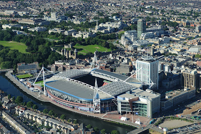
Flying the week before the Olympics got started also allowed the Royal Commission to document key Welsh sites involved in the games for the National Monuments Record of Wales including the Wales National Velodrome at Newport, where Team GB were practising at the time of the photography, along with the Millennium Stadium in Cardiff the day before the Olympic football tournaments began. As with the recently acquired historic Aerofilms collection for Wales, these images will form a permanent record in the National Monuments Record of Wales of transient cultural and sporting events so important to Wales in 2012.
 | |||||
| A wide view of the Wales National Velodrome (white roof next to running track) AP_2012_3189 |
 |
| Millennium Stadium in Cardiff, NPRN: 309686 |
 |
| Burry Holms , NPRN:301302 (right foreground ) and Worms Head NPRN: 305465, AP_2012_3280 |
See other aerial views of Wales, dating from the 1920s to 2012, in the Royal Commission’s new book Cymru Hanesyddol o'r Awyr / Historic Wales From the Air by Toby Driver and Oliver Davis.
For sporting fans Fields of Play: The Sporting Heritage of Wales by Daryl Leeworthy will soon be available with a 10% discount for Friends.
Subscribe to the Heritage of Wales News and sign up for the full feed RSS, just click this
 RSS button and subscribe!
Also find us on:


Twitter Hashtag: #RCAHMWales

0 comments:
Post a Comment
www.rcahmw.gov.uk
Please comment and let us know your views or your news. Remember that what you write can be read by everyone. RCAHMW reserves the right not to publish offensive or inaccurate material.